This story will be a bit of a diversion from the articles on last years #biwipowproject that I started posting last week as hype builds up for winter 16/17. As some of you know, after a long period just on dry land or at altitude, I finally had some time and saved up sp,e money to go surfing. After two years I finally returned to the island of the gods, my beloved Bali. But I can not leave mountains be. That`s why I also wanted to claim one of the highest peaks in Indonesia. Mt. Rinjani. But mother nature it seams had other ideas…
My plan was simple. During my good two weeks of surfing on Bali I would take the ferry to Lombok and take part in a three day trek to the peak of mount Rinjani. I travel light when going to Bali. That is why I also packed my La Sportiva Nepal shoes in my spacious Ferrino Chilkoot 75 trekking backpack. As the temperatures at altitude get cold quickly I also packed my trusted Ferrino Vladez Jacket and my Mischabel Down Jacket. Ready for anything mother nature could throw at me. Except for one thing…. a volcano eruption.

As I landed at the horrible Jakarta airport I got a massage that the final leg of my journey to Bali would be delayed for a good 5 hours. The small Vulcano in the middle of one of the best scenic Lakes on Planet earth on Lombok Islands Mt. Rinjani had decided to say “Hi! Im still here!”. So did three other Volcanos in the “Ring of fire” that crosses trough Indonesia. Of course the whole area of the Rinjani Volcano was closed off after the eruption. My original plan was doomed from the get go.

After spending a couple of days on the island I had already somewhat given up on my mountaineering plans. It is already October and Rain season draws closer. Daily showers and Thunderstorms are the norm now so getting a good weather window is very hard. Then last Wednesday after a somewhat demoralizing early morning surf session that left me with a nice fin cut on my left knee I was checking options to gain some altitude.

There are two Vulcanos worth checking out on Bali. One is the Batur Vulcano, relatively low and easy. A walk in the park with a nice view. The other is the seat of the gods. Mt. Agung. A Stratovulcano that goes all the way up to 3148m. This one has two ways up but only one leads to the real summit. After learning that it is forbidden to go up without a guide I quickly used google and found myself a nice arrangement on Voyagin with the local agency Bali Sunrise Trekking and Tours.

Because of a short weather window that would last only until mid day on the next day I was unsure if it was doable. Looking at the forecast for the coming week it was clear. Now or never. A few emails and a few hours later at 9 pm, I got picked up by my driver. A cool local Balinese dude with the best dance music playlist I ever heard 😛
The ascent

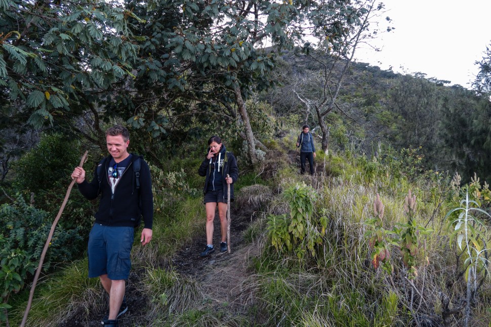
It took us a good two hours to reach Bali`s most sacred Temple grounds, Besakih temple fom Seminyak by car. At an altitude of around 900m this would be the starting point of our trek. We were a bit late so we arrived in utter darkness. One could see the stars. That was a great sign for my plan to peak on sunrise. First I thought that I would be the only one to do the track on that day. The recent stormy weather would have deterred anyone but the most aspiring mountaineers. But there were other cars at the parking. A guy from Singapur and two girls form the Netherlands Thea and Patty, a dynamic mom and daughter duo, both happy to see another European. After all this is Indonesia. You never know exactly what the word guide and safety mean in local interpretation.

After a bit of waiting the guides arrived. They were very diverse. Our two looked properly equipped. They were both very fluent in English too. That was something that had worried me a bit at the beginning as my Bahasa Indonesia stops at “Sampa jumpa!” :P. The path itself started off at quite steep in the jungle. It must have been sometime past midnight. Palm trees and lots of weird fauna around us. The trail was full of slippery wines and lots of scree. It had rained heavily the days before. That made the trail a bit more stable. It was a really good idea that I brought my proper mountain shoes.

We were making good time and the girls were also doing great. The trail itself was well maintained for Indonesian standards with occasional helpers like wines to get the hikers trough the hard spots. We took our first brake at the first little altar where the guides lit a few offerings to appease the mountain gods. They were also nice enough to supply us with mountain sticks and rations.

One of the guides who at the beginning I thought was slacking of by taking power naps was also accompanied by his cool little white dog. The dogs name was Putih. That means white in Bahasa Indonesian. Like his owner Putih was also taking small power naps in the best places on our way up.
As we were getting higher and higher the constant incline and the spree were staring to effect our little group. The girls were getting a bit slower. But I have to say the trail was quite a complex one. I would not recommend it if you are not a avid mountain goer. I was already thinking how awesome it would be to do a speed ascend with my normal gear. My Salomon Speedcross shoe would be awesome for this.

As for my gear, my Ferrino Chilkoot 75 backpack was surprisingly comfortable for mountineering. It was mostly empty since it had 75 l of space but I could fasten it all so that it stayed nice and compact. Ferrino did a good job on this one. Also the front access pocket made taking food out easy. I also had my H2O pack in it so there was no need to take out any bottles. There was only one problem. I put my medical stuff, including iodine in the main pocket. The Iodine flask was crappy so I ended up spilling it on half my cloths in the backpack. Fortunately it did not get on my technical gear.

While ascending up I had struck up an interesting conversation with the power napping guide. He told me that he does this trek around 5-6 times a week with different clients. Europeans are usually reasonably fit but Asian guests usually do not make it past half the mountain. I remembered the Singaporean guy from the parking lot. He had turned around after a good hour. Exhausted already. I also learned that my guide loves running up and down the mountain. His record for going up was a good 3 hours and 10 minutes. He could make the descent in 1 hour and 15 minutes. I reckoned that we would not beat the time up with this group but as we talked he was up for running down the mountain. I was too. After all the longer we were walking the 8 km trail the better it was getting 😛 He was also the quickest and fittest of the guides.

Somewhere along the way a group of four Germans from another tour operator had joined us. They were doing ok too. But there was one problem. Stamina. As the hike totals on about 13-14 km and around 2200 hm up alone it becomes a game of who can last. As we were approaching the treeline the fauna was changing. Trees became smaller. Dense jungle became grass. And the view was getting more insane with every meter. You could see it all. Flickering lights of civilization on the whole island bellow and the billions of little starts above. Truly a magnificent. The air was also fantastic in comparison to the Denpasar smog bellow.
Running to the peak

As we reached another temple the spree gave away to proper rock. Volcanic rock. Super grip and claimable/ runnable. The Vibram soul of the Nepal mountain boot was really sticking to everything here. We were also now a good 500 hm under the summit. The others were already quite exhausted. Then the guide asked me if I wanna run up to the top. As I usually do around 700 hm in 30 minutes while chasing after Jan I figured why not. The hike might have been long but I was not that tired. That is when we set off.

To make it to the real peak for the sunrise we would have to be quite quick. After the long constant ascend there is still 800 meters of ridge to cross if you want to make it to the edge of the crater and it`s highest point at 3.148m. Our tempo was awesome. The guide estimated a good 40 minutes to the top.
We also came to a section where the diretisima meant climbing a little technical wall. I would reckon it a two in mountaineering terms but it was super fun. The guide told me that he would like to have more of these but for safety the normal trail is laid out to leave these little jems out. The higher we got the darker the stones were. The combination of dust, spree and volcanic rock was amazing. It looked more like a old coral reef then a rocky mountain. It was also super fun for placing fast steps.


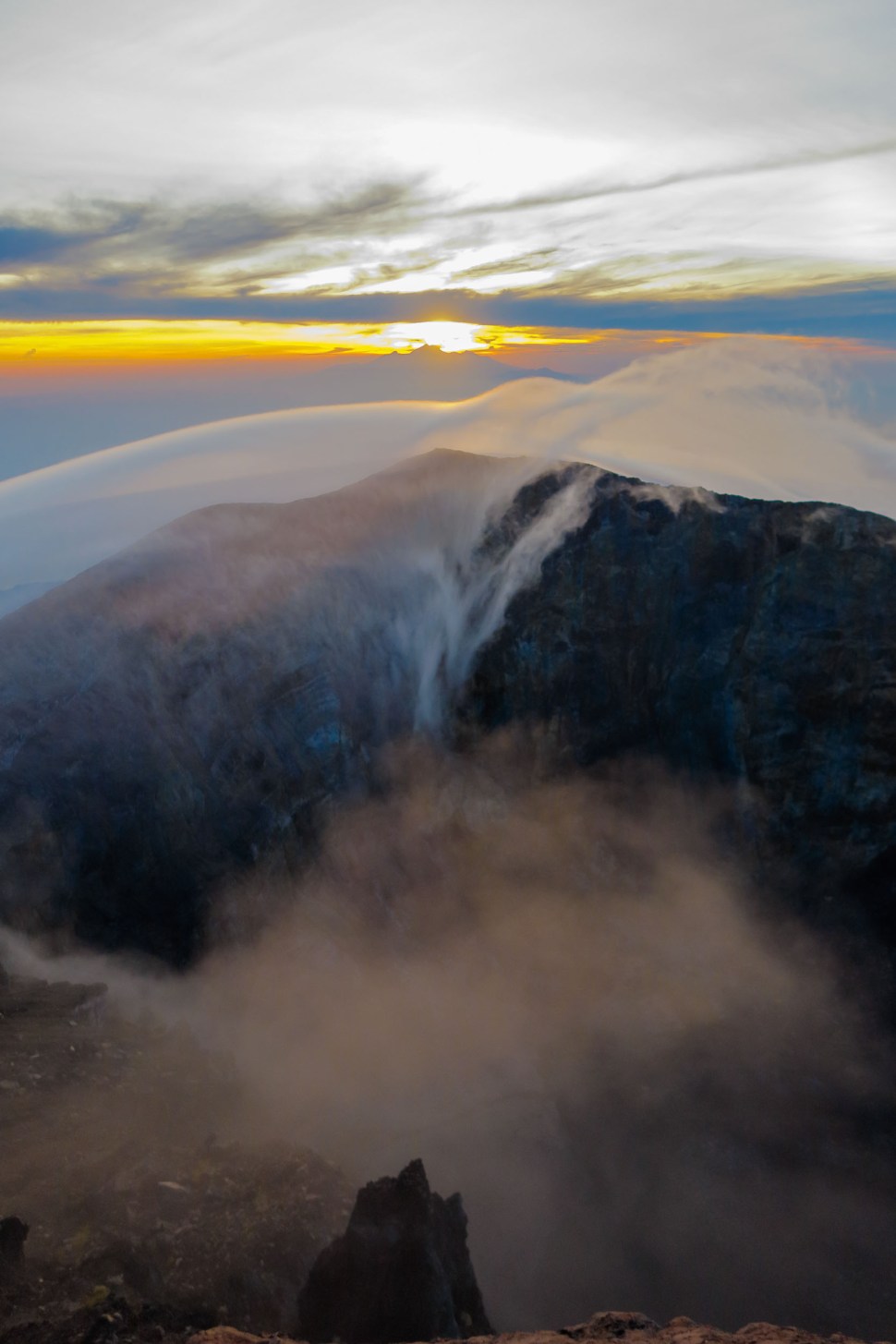
With twilight rising on the horizon we were at the ridge. We quickly made our way on the last 800m and a good 15 minutes before the sun finally rose behind Mt. Rinjani on the other side of the Lonbok straight we had made it to the top. This was one of those sights that I will remember forever. I also took a picture that is probably one of my best nature photographs. Wind picked up and the temperature was a nice 6 degrees. I put on my Ferrino Valdez jacket and my down so as to stay warm.

Putih the dog also found a nice wind shielded place to do another power nap. We took a few more pictures and as the day began so did our descent.
Descent on Trailrunning terrain

As we were returning on the ridge the guide told me that I had been the first in a good week to make it to the peak and that the others had turned around from exhaustion. After all you have to make it up and down. Soon we caught up with the group. The Germans were descending nice and slow with a bit of battered pride but they were in good spirits. They were from the Saarland. So not form the mountain part of Germany. They were happy with what they achieved and would celebrate it with a well earned beer. The girls from the Netherlands were exhausted but descending steadily. Patty told me that they were looking forward to a good massage after returning to their retreat.
The head guide came to me and also said that he never saw anyone run like a guide up the hill before with his friend. He was amazed. He said I must be crazy like his friend. That was a compliment I gladly took. But the fun was not over yet. My guide friend was still up for running down the hill.


At this point I was thinking that it probably is not a good idea to run down a technical trail with lots of obstacles with a heavy inflexible badly cushioned mountaineering shoe. But being me, forever a child, playful and pumped up I said “What the hell this will be fun!”. We would not beat the 1 hour 10 minutes but we could still make good time.
We started off quick. It was funny how the changing surrounding flora, spree and stone were influencing the way were running. The Nepal is the best shoe I have ever had hands down. But it is definitely not made for running. If you ever ran down a snowy slope in ski boots then you will know the feeling I had for the more then 2000 hm back on the way to the bottom.

We got into a good tempo and soon passed the first temple. Now in daylight you could see that the trail ran on one of the many ridges of the Volcano. On either side there was steep fall off. If there was ever winter here the upper part of the Volcano would be epic powder grounds. After a good 1 hour and 45 minutes we were at the bottom and my plan had been a success. According to sports tracker we had totaled 4348 hm up and down. So it was 2174 to go up. Total time of the whole adventure was around 8 hours.

After saying our goodbyes my driver was back. He took me to lunch at a restaurant with the best view I had ever had while eating food. Then it was time to get back to Seminyak. I had an awesome time on this track and it was also the first time I ever payed for a guide. The guides here were a lot better then I expected. They looked well after their guests to keep them safe. Helped them with the ascend and even adapted to my tempo. All in all this adventure was defiantly one of the better once this year, so if you are looking for a challenge when you come visit Bali take the time, pack good boots and go visit the gods at the peak of Mt. Agung.
Ales – this is the best ascent write up of a Bali mountain I’ve read! Been searching for a great guide who is up for turning on the trail running for mt agung. Do you have a contact you could share? Thx so much. george
Hi George ! Sorry for the late reply. I have not had a lot of time for the blog lately. Unforitonatly I do not know how the situation is form last year when Agung eruptet. That was probably the last year the peak looked like it does in the photo. What I can give you is the contact to the agency I booked. Ask for the guide with Puta the white dog 😛 they should know :). Here is the link. I actually did not do super much research on the guiding company as I actually booked the tour because u are not allowed to try the ascent unguided. Here is the link https://www.govoyagin.com/activities/indonesia-bali-hike-up-mount-agung-bali-highest-peak/2885. I did the long one that starts from Besakih! Itr was deifnetly the best adventure I had in indo while not surfing 🙂 also its 2100 hm so its a grind. And take your proper hiking shoes!